Piton de la Fournaise, literally meaning, Peak of the Furnace, is actually a shield volcano situated on the eastern part of Réunion Island in the Indian Ocean. Presently it is considered as one of the most active of all the volcanoes of the world, the others being, Kilauea in the Hawaiian Islands, Stromboli, Etna and Mount Erebus. A most recent of the eruptions started in August 2006 and came to an end in January 2007. It again erupted in February 2007, as well as on 21 September 2008. Most recently, an eruption happened on 2 January 2010 and continued for ten days. Popularly known as le Volcan or The Volcano, Piton de la Fournaise is an important tourist spot on Réunion Island.
Piton de la Fournaise – History
Believed to have been originated in an era about 530,000 years ago, Piton de la Fournaise is a distinct instance of a hot-spot volcano. In the major part of the course of this time, its activity coincided with the eruptions of its larger and older neighbor, the severely eroded Piton des Neiges shield volcano on the NW.
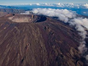
Three calderas were created respectively at approximately 250,000, 65,000, and less than 5000 years back by progressive eastward bending of the volcano. Several pyroclastic cones are found scattered on the floor of the calderas as well as their outer boundaries. Most of the historical eruptions were born out of the summit and borders of Dolomieu, a lava shield of 400 meters in height and which has grown inside the youngest caldera known as the Enclos, which measures 8 km in width and goes down to underneath sea level on the eastern face. Over 150 eruptions, majority of which have given out fluid basaltic lava flows, are found to have taken place from the 17th century. Just the six of the eruptions, in the years 1708, 1774, 1776, 1800, 1977, and 1986, are said to have been born from fissures on the external borders of the caldera.

On the uppermost part of the volcano there is the Enclos Fouché, a caldera which is 8 km in width. High cliffs, called ramparts constitute the borders of the caldera. The caldera breaks to the southeastern part into the sea. It is not in a very steady position and seems to be in the early stages of crumpling and will ultimately fall down into the Indian Ocean. Evidences of earlier failures are prominent on the submerged flanks as well as abyssal plain. The lower slopes are called the Grand Brûlé. The majority of the lava eruptions are restricted to the caldera.
A number of craters as well as spatter cones are found within the caldera and also on the outer boundaries of the volcano. Towards the opening of the path leading to the summit, you can find a clearly visible small crater called formica leo.
Some of the beaches at the Piton de la Fournaise sport a greenish shade owing to the olivine sand effecting from picrite basalt lavas. The Grand Brûlé has been created out of hardened lava flows that had accumulated through several ages; the most recent eruptions are found to be the darkest in color and largely vegetation-free, whereas, some of the previous ones are covered by thick wild vegetation.

Visit Piton de la Fournaise
To visit the site of Piton de la Fournaise you can take the forestry road, followed by a good track, which links the plains highway in Bourg-Murat with the pas de Bellecombe.
A good staircase path comes from the pass down to the floor of the caldera. This path remains closed for security reasons at the time of seismic events that can possibly occur before or during eruptions.
Although expensive, an excellent way to the site to get a good view of the volcano is to take a ride in one of the tourist helicopter flights that are on offer by the various commercial companies located on the island.
Take the N2 highway to visit the lower parts of the Grand Brûlé. The path signs are indicated by the lava flows that cross the road.